
The US is a massive country with thousands and thousands (and thousands) of beautiful hiking opportunities! Personally, we think some the best of them are located in Southern Utah. We drove through this stunning state this past summer on a cross-country road trip and we were simply blown away! We spent just over 1 week between the three areas of Moab, Bryce Canyon, and Zion camping in our truck & hiking every chance we got. We gave ourselves 2 1/2 days in Moab and here’s how we maximized our time in this arch-filled wonderland.
MOAB
A mentioned earlier, we experienced Utah on a cross-country road trip this past June. We were driving East to West from North Carolina to California, so when we entered the state of Utah we chose to start in Moab. Moab is actually a decent sized town with a main ‘strip’ hosting dozens of restaurants, bars, rental shops, & more. We arrived around 10pm into town with every intention of car camping, but Mother Nature had different plans; howling winds, thunderstorms, and flash flood warnings made us think twice about parking off the grid and so we settled by booking a hotel room for 2 nights at the end of town called the Aarchway Inn.
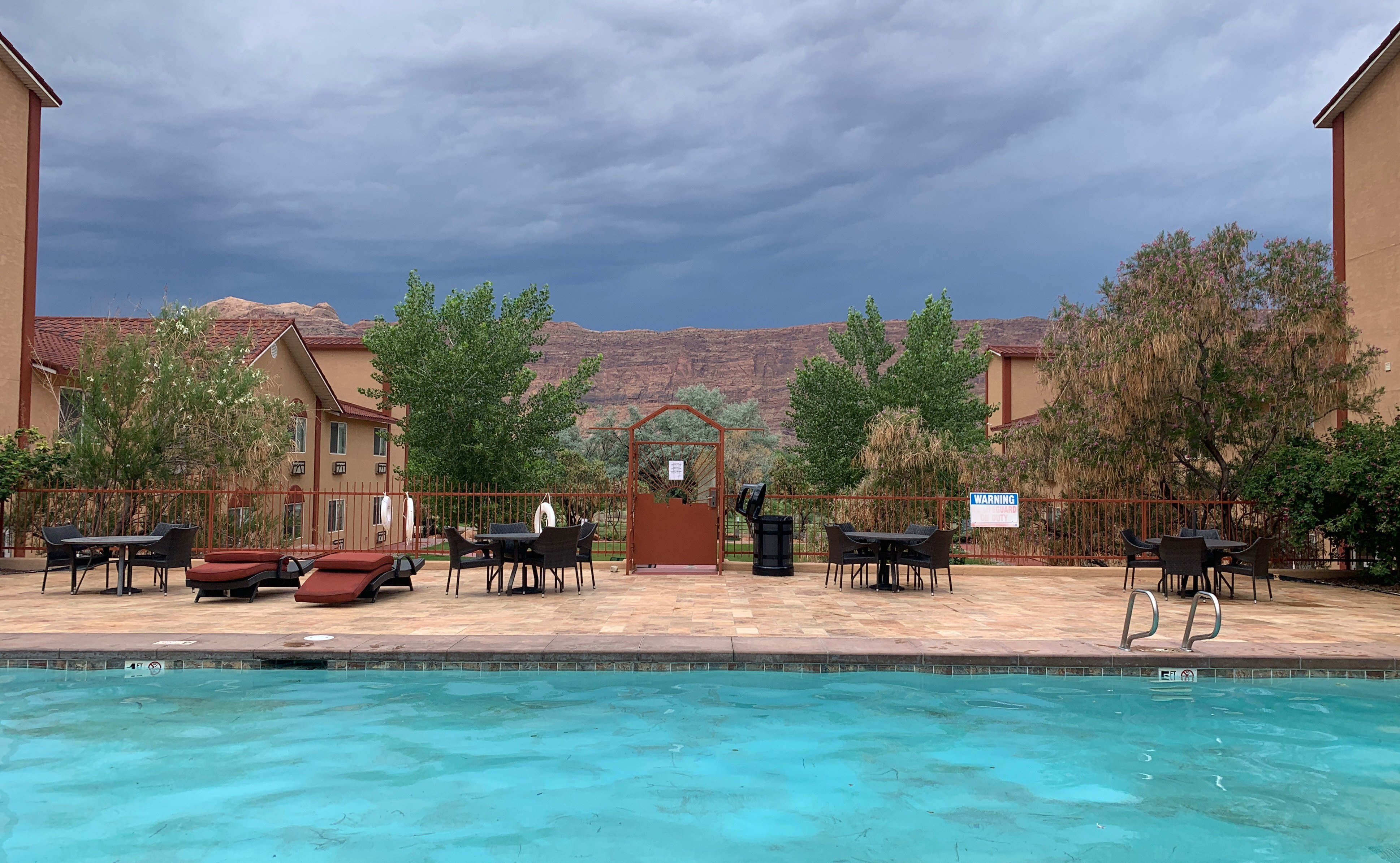
We found the hotel by searching last minute on hotels.com and chose it because it looked clean, had free breakfast, a laundry area, and was super close to Arches National Park (2 miles to the entrance). We were seriously impressed with this place for the cost and found it to be an extremely good deal. A short list of amenities includes : outdoor pool, hot tub, horse shoe course, playground, basketball courts, and a beautiful river walkway.
In the end it worked out perfectly to stay a few nights in the hotel since aside from the nasty weather, we had been car-camping for 7 days leading up to that point and as you can imagine, really needed a shower & to wash some clothes.
DAY 1: ARCHES NATIONAL PARK – PARK AVENUE & DELICATE ARCH TRAIL

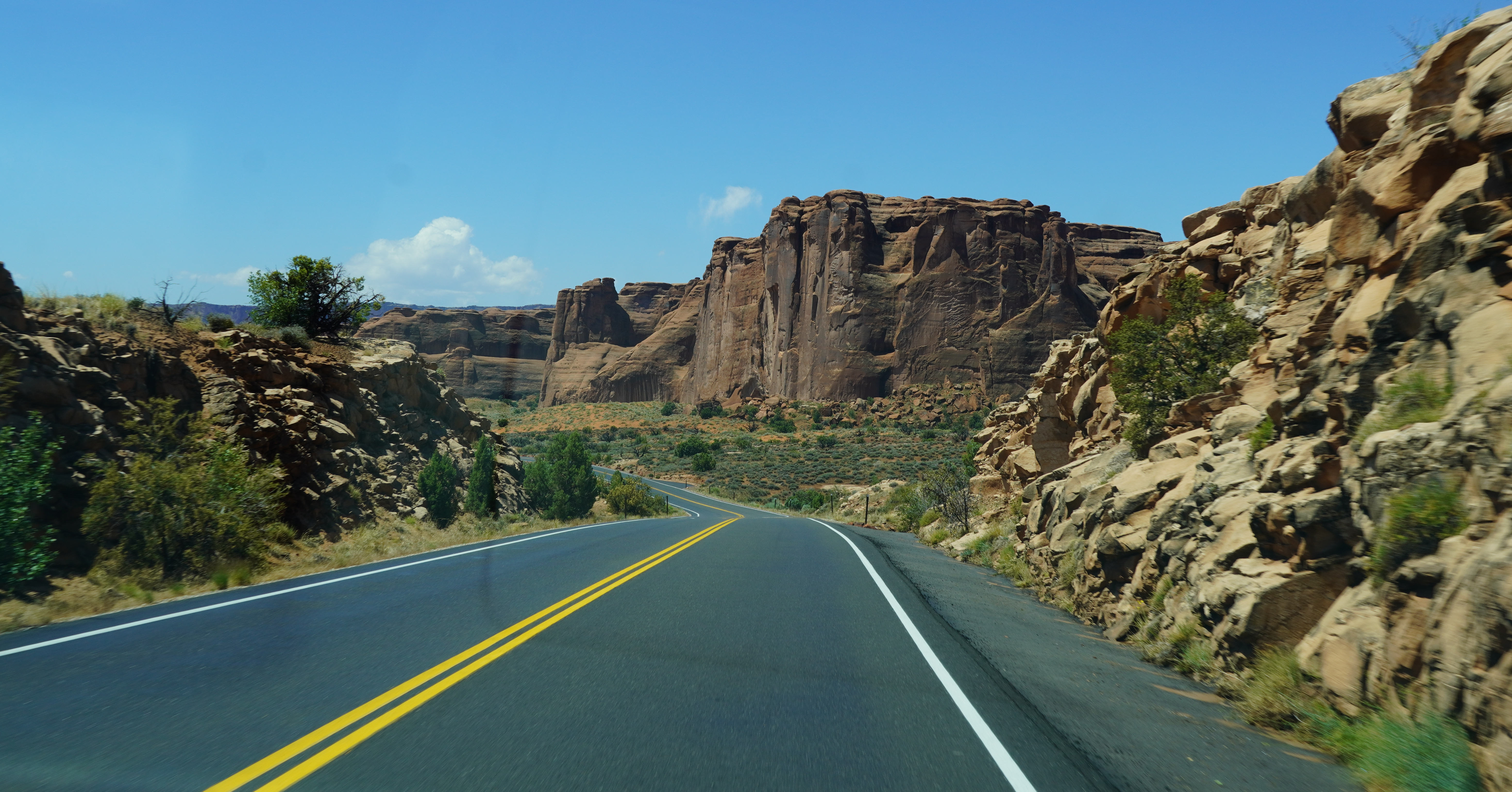
We woke up well rested and partook in the complimentary hotel breakfast before doing a load of laundry. The storm was till passing through that morning and lighting, hail, and gusting winds were not exactly ideal hiking weather. But instead of wasting time while the weather passed, we thought it would be cool to see Arches National Park in the storm! The National Parks system has done a wonderful job maintaining excellent paved roads throughout Arches NP and other parks in the area and you can reach a surprisingly large amount of the park without ever having to leave you car.

So we hoped in the truck, then made the short 5 minute drive to the entrance to Arches NP. Due to covid-19, the parks were operating with a limited staff and therefore weren’t charging an entrance fee! They offered us a free park map & cautioned us to watch for washouts and debris in the road due to the storm.

As we drove up the first turn, the rain was really coming down and we couldn’t believe what we were seeing: gushing red waterfalls all along the tops of the rock formations. We continued in, pulling off when possible to watch the lightening and take in the natural beauty that was all around us. We continued along Main Park Road, veering right to the parking lot for the Delicate Arch Viewpoint.
At that time, we could see the edge of the storm and blue skies behind it and decided to take a quick climb up to the lookout. Although it was in the distance, Delicate Arch looked magnificent. Since we needed to head back to the hotel to swap our laundry, we decided we would come back and hike to it for sunset. We drove back the way we came, sun shining bright now, feeling like we scored getting to see the park in the storm.

Laundry was finished, we were cleaned up, ate some leftovers for lunch, and after a few adjustments to our packing situation in the truck bed, we cruised back into Arches around 3pm to get in some hiking.
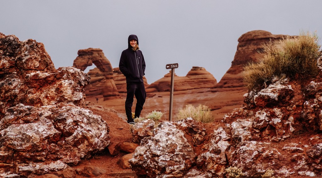
We started with a quick jaunt down Park Avenue which is an easy stroll with some jaw-dropping slim rock formations jutting up all around you. Since we wanted to make sure we got to Delicate Arch before sunset, we cut Park Avenue to a short 15 min walk before driving 10 minutes to the start of the Delicate Arch Trailhead. The parking area was already nearly full at 3:30pm (sunset was at 7:35pm in June) so we were happy we arrived when we did.

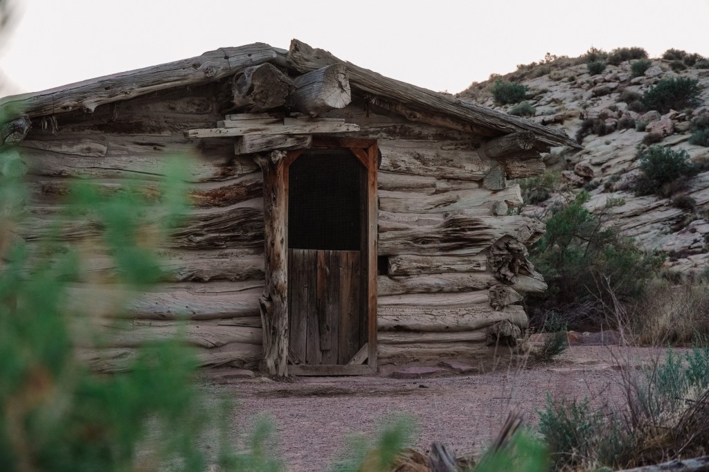
We packed a day-bag with two 24oz. water bottles, our camera & tripod, a towel to sit on, some cheese & crackers, a bottle of wine, and two glasses (hey, if we were going to hike all that way up we sure were going to enjoy the view once we got there!). The trail to see Delicate Arch up close and personal is 3 miles (4.8 km) roundtrip and climbs 480 feet (146m) and takes an estimated 45min-1hour each way. Along the steadily uphill trail, we passed the Wolfe Ranch cabin and a wall of Ute Indian petroglyphs.
For people in decent physical health, you’ll make this hike without issues. But those with small children or those not in great physical shape, it will be more of a challenge due to the steady incline the entire hike to the Arch.
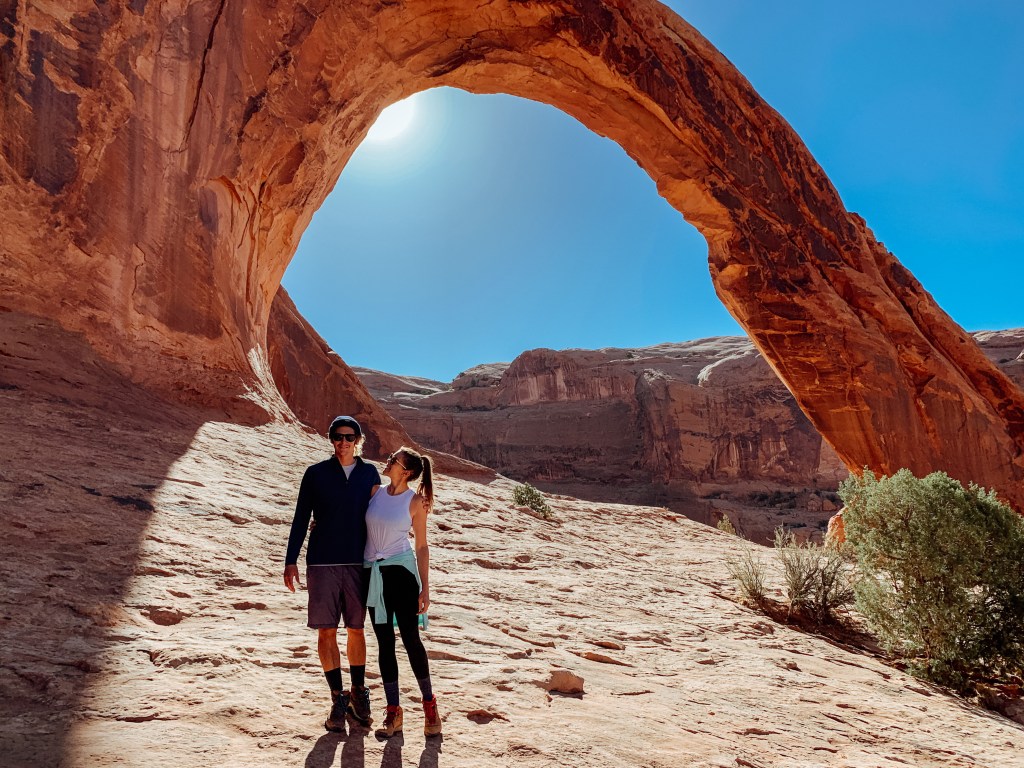
Delicate Arch is totally hidden until after you round the very last corner of the trail, then WHAM. It’s right there. Across a giant rock bowl made by none other than Mother Nature herself. It’s massive: the light opening beneath the arch is 46 feet high and 32 feet wide, making it the largest free-standing arch in the park. But being the largest also means this arch is definitely the most popular to see, especially at sunset…

It was a little disappointing how busy it was at Delicate Arch that evening. But, we made the journey and figured we should hang around and enjoy the setting sun and our wine + cheese we lugged up there. We found a great vantage point away from the crowds and set-up a little picnic with a perfect view of the Arch. We managed to snap a few shots with the massive Arch before packing up our things and heading back to the truck. We didn’t stick around for the actual sunset since we did not want to get caught in the mob of people all leaving as soon as the sun went down. We do recommend bringing a headlamp with you on this hike if you go for sunset since it gets very dark, very quickly and the footing can be tricky in some areas.

We made it back to our truck as the sky turned pink and we enjoyed a leisurely cruise out of the park, enjoying the changing colors of the rock formations in the distance. We found a great mediterranean restaurant to eat some dinner, Sultan Restaurant, before returning back to the hotel for some much needed rest.
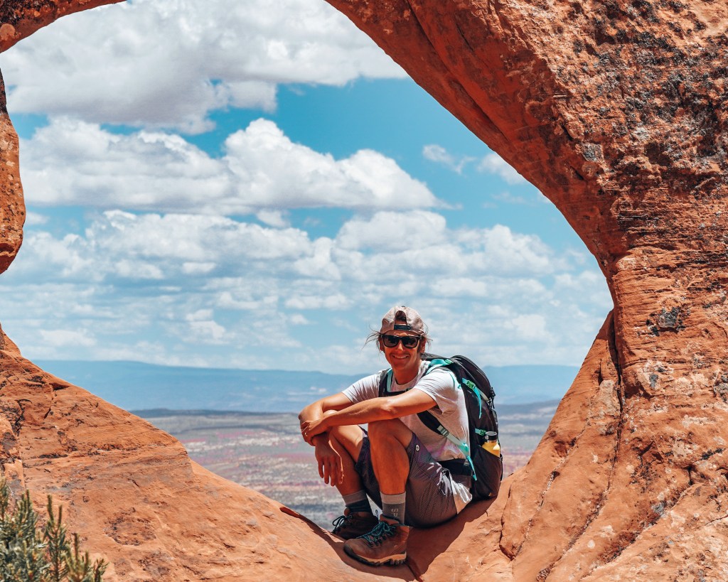
DAY 2: ARCHES NATIONAL PARK – DEVIL’S GARDEN TRAIL
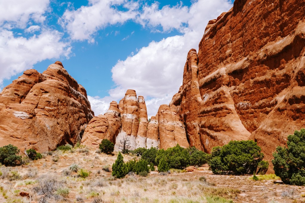
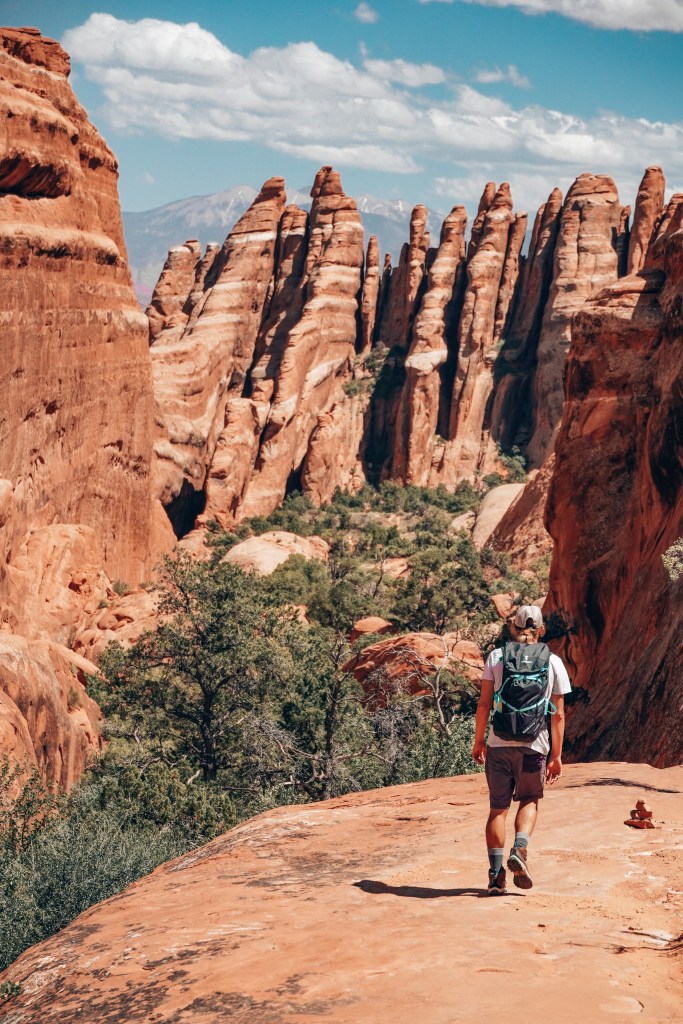
We woke up early to pack up our things since we would be checking out of the hotel that day and camping outside of Moab that night (exactly where, we weren’t yet sure). Again we ate up the free breakfast before packing up the truck and heading back into Arches for a longer, more strenuous hike – Devil’s Garden. A mysterious name given to an adventurous trail made for sightseers, hikers, and thrill-seekers. This trail head is located at the very end of the park (18 miles-45 min drive) so plan accordingly. We had read this bike offered views of several arches, spires, and a large concentration of narrow rock walls called “fins” that require hikers to scramble a bit to get around them.

There are several ways to tackle Devil’s Garden Trail and you can hike as little or as much as you like. Since we had only completed 2 shorter hikes the previous day, we wanted to challenge ourselves with this one and chose to hike the entire trail system in this section, totalling an estimated 12 miles. This hike is nothing to mess with and we highly recommend packing plenty of water, lunch, & extra snacks (& a headlamp just in case) to make sure you stay safe along the way.
We really enjoyed this trail since a lot of other hikers seemed to stay close to the start of the trail, turning back after the first set of arches, leaving us to hike completely alone for most of the day! A total change from the Delicate Arch hike the night before. The highlights of Devil’s Garden are Landscape Arch, Navajo Arch, Partition Arch, Double O Arch, Dark Angel Monolith, Private Arch, and of course all the rock wall ‘fins’ along the way.
Small rock piles signal the direction of the trail, but often times these can be difficult to spot or go missing after heavy rainfall. We got lost quite a few times but managed to find our way back on trail eventually. We made it out dusty and grinning ear to ear in just over 5 hours and rewarded ourselves with a cold beer on the tailgate in the parking lot (one of the many benefits of living out of your truck).

Although it was still relatively early (3pm), we had to get moving to find a campsite for that evening. The campgrounds within Arches NP were all closed due to Covid-19 restrictions and we had heard other campgrounds were closed as well, leaving us not many options. We left Arches NP and crossed over the Colorado River before making a right on Kane Creek Blvd which hugs the river heading south out of town.
We had pinned a few riverside campsites (King’s Bottom & Kane Creek) using the iOverlander app (a game changer for wild-camping enthusiasts, download it now!) but when we arrived at both they were already full. It was at this point we realized we seriously messed up: we weren’t aware of the campsite reservation system in Utah. You are allowed to drive around and submit to reserve campsites a few days up to a few hours ahead of time by simply filling out a little piece of paper and dropping your money into a slot.

Damnit. Everyone else had done that this morning and now it seemed like every campsite was already spoken for. Ughhhh, what are we going to do?! Well, although we were frustrated and feeling a little defeated, we never give up (and we had to sleep somewhere). So we continued on Kane Creek Blvd until the road split and we followed it east away from the river. The paved road abruptly became dirt and before we knew it, we were driving along the edge of a very deep canyon. It was insanely beautiful but also slightly terrifying.
The road wound around the rim and started to descend into the canyon. I could see on the iOverlander app that there were a few more campgrounds up ahead and so we just kept going. We felt like we were in an Indiana Jones movie, cruising this red dirt road along the bottom of a canyon. It was epic.

We passed another campground area that was (again) spoken for and at that point agreed we would only attempt 1 more campground before turning back and heading into Moab to find another option. The road funnelled out of the canyon and into this giant open range, red plateaus jutting up in the distance. Finally we arrived at The Ledge Campgrounds and couldn’t believe our eyes: it was EMPTY. At first we thought it must be closed. Why else wouldn’t there be anyone here?

So we drove through the entrance, scoping the area and looking for any sign of why we shouldn’t camp here. We circled the entire grounds and nothing seemed amiss so decided this was it, we found our site! We slipped our money into the ranger’s box & picked our site. Nestled against an enormous red rock wall, we parked the truck and set up camp. It felt like all that driving around earlier was made worth it by this epic campsite.
We cooked cast iron pizzas for dinner and enjoy a few beers while the sun dipped below the horizon. We played with our light-up frisbee & lounged around our portable gas fire pit until the time was right for some star gazing, and man were we in awe. It was such a magical feeling being alone out there in the middle of the desert, an experience we won’t soon forget.
DAY THREE: CORONA & BOWTIE ARCH HIKE

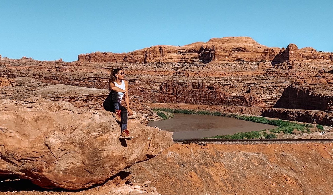
We awoke to silence. It was almost scary, but mostly amazing. Stefan whipped us up some coffee with the french press and we ate a quick breakfast of oatmeal before packing everything up and saying goodbye to our special campsite. A friend of ours had recommended a hike outside of the National Parks called Corona & Bowtie Arch. We hoped the trail would be less crowded due to it’s location and we wanted to hike it early since we were driving to Bryce Canyon right afterwards.
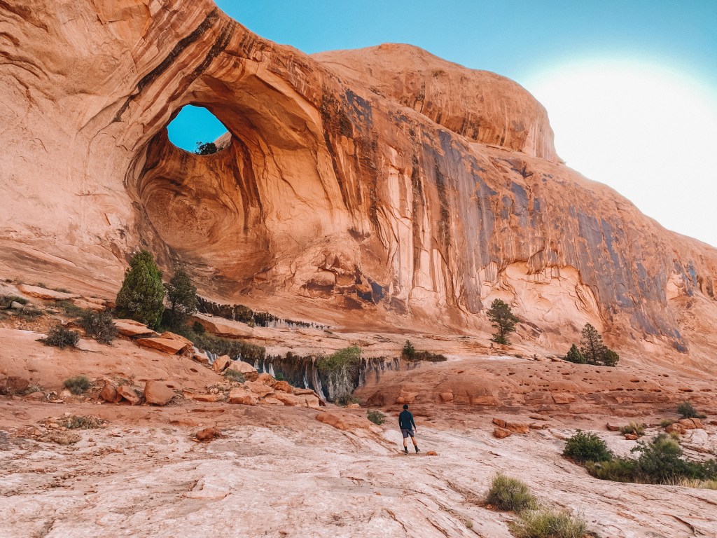
Located just on the opposite side of the Colorado River from where we camped, the trailhead is signed and is about 10 miles down Potash Road. When we arrived, there was only 1 other car in the lot which is always a great sign. The route to these two arches makes one of the best short hikes in the Moab area. The hike crosses open slickrock to a ladder bolted to the rock wall. A quick climb up, a shimmy across more slickrock, & up a few steps cut into the rock with an assisted cable, and you’re there! The hike is 3 miles roundtrip and worth every step.
We were the only people out there that morning and we couldn’t have asked for better weather. It was a dream hike and recommend it to anyone in the area! We passed a few hikers on our way back down the trail, all extremely friendly and happy to be out in nature.
We stocked up at the local grocery store with food & supplies before hitting the road through Escalante National Park on our way to Bryce Canyon! Stick around for our Bryce Canyon & Zion recommendations coming soon!
